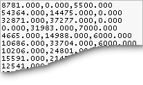
Instead of modeling, you can read the terrain point coordinates from a file, which can be of TXT, CSV or SOS format. In TXT and CSV files, the Z, Y and Z coordinates of each point are on their own lines separated by commas. A TXT file may look like this, for example:
![]() The coordinates are specified in millimeters in the file. If you
are using the Imperial system, the coordinates are specified in
inches.
The coordinates are specified in millimeters in the file. If you
are using the Imperial system, the coordinates are specified in
inches.
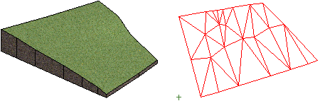
The terrain is modeled in the model window. If you selected the Draw mesh of points in 2D checkbox in the terrain properties (on by default), the program will draw a mesh of points in the drawing.
| Converted from CHM to HTML with chm2web Pro 2.85 (unicode) |