- Select terrain points.
- Select
 Selecting of points from the
contextual toolbar.
Selecting of points from the
contextual toolbar. - Select the height definition method from the contextual
toolbar:
 Absolute Z-Height - Specify a point's height in
relation to the absolute zero level.
Absolute Z-Height - Specify a point's height in
relation to the absolute zero level. Relative Z-Height - Specify a point's height in
relation to the terrain's base Z-height.
Relative Z-Height - Specify a point's height in
relation to the terrain's base Z-height.
- Enter the height of the terrain point in the z field in
the contextual toolbar.
 Enter the height in meters. If you are using the
Imperial system, enter the height in inches.
Enter the height in meters. If you are using the
Imperial system, enter the height in inches. - Select a point in the drawing. Select, for example, a corner point of the lot.
- If necessary, enter a new height and select a point.
- Select
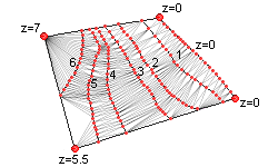
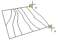
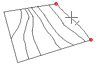
- Select elevation curves.
- Select
 Selecting of lines from the
contextual toolbar.
Selecting of lines from the
contextual toolbar. - Select the height definition method from the contextual
toolbar:
- Absolute Z-Height - Specify a curve's height in
relation to the absolute zero level.
- Relative Z-Height - Specify a curve's height in
relation to the terrain's base Z-height.
- Enter the height of the elevation curve in the z field
in the contextual toolbar.
Enter the height in meters. If you are using the
Imperial system, enter the height in inches. - Select a line in the drawing.
- If necessary, enter a new height and select a line.
- Select
By switching the selection method, you can alternatively select either points or lines in the drawing. First select the selection method and then enter the height in the z field.